|
Positioning
The literal meaning of positioning in the context of cellular networks is to figure out the location of a device, such as a mobile phone. With 5G, this process goes beyond what traditional GPS offers by harnessing the network’s own infrastructure—base stations, antennas, and sophisticated algorithms—to determine a device’s position with impressive precision. By utilizing high-frequency bands, massive antenna arrays, and ultra-low latency, 5G positioning enables real-time tracking and powers
innovative applications
like self-driving cars, smart cities, and augmented reality. For those working in the field, it’s a fascinating blend of connectivity and spatial awareness, turning signal data into a tool for understanding where devices are and how they interact with the world around them.
As we advance into 5G and beyond, "positioning" transcends simple location tracking; it's a critical enabler for a multitude of applications, from enhanced navigation and asset tracking to precise industrial automation and immersive augmented reality experiences. At its core, positioning in cellular networks involves determining the geographical location of a user device or object with varying degrees of accuracy and reliability, leveraging the network's infrastructure and signaling.
Understanding the nuances of these positioning techniques, their strengths, and limitations is essential for anyone working in the development, deployment, or utilization of modern cellular technologies.
Positioning technology in cellular networks is the art and science of determining a device’s location (e.g, a smartphone or IoT sensor) using the network’s capabilities. It has grown from basic methods relying on proximity to a single tower to advanced systems that harness multiple signals, precise timing, and even artificial intelligence. This evolution reflects a journey from coarse approximations to pinpoint accuracy, driven by the needs of applications like real-time tracking, indoor navigation,
and smart infrastructure. For professionals in the field, it’s a fascinating challenge - combining signal measurements, environmental data, and computational power to transform connectivity into a tool for understanding where things are, no matter the setting or complexity.
|
Technique
|
Description
|
Pros
|
Cons (Challenges)
|
|
Cell ID (CID)
|
Determines the device's location based on the serving cell's ID.
|
Simple, widely available, works in all networks.
|
Very low accuracy, depends on cell size.
|
|
Enhanced Cell ID (E-CID)
|
Enhances CID by considering signal strength, timing advance, and neighboring cells.
|
More accurate than basic CID, utilizes additional network data.
|
Still limited by cell radius; not precise in dense environments.
|
|
Triangulation
|
Determines location by measuring angles from at least two known reference points.
|
Does not require precise time synchronization; useful in network-based positioning.
|
Requires at least two reference points with known positions; affected by signal reflections.
|
|
Trilateration
|
Determines location by measuring distances from at least three known reference points.
|
More accurate than triangulation; works well with GNSS and cellular signals.
|
Requires precise distance measurements; affected by environmental interference.
|
|
Time of Arrival (TOA)
|
Measures the time taken for a signal to travel from the device to a base station.
|
Provides relatively accurate distance estimation.
|
Requires precise timing synchronization; affected by reflections.
|
|
Time Difference of Arrival (TDOA)
|
Uses the time difference between signals received at multiple base stations to estimate location.
|
Higher accuracy than TOA; works well in urban environments.
|
Sensitive to signal interference and multipath effects.
|
|
Angle of Arrival (AoA)
|
Determines location based on the angle at which signals arrive at base stations.
|
Effective in multipath environments; useful for angle-based applications.
|
Needs multiple base stations and precise angle estimation.
|
|
Received Signal Strength Indicator (RSSI)
|
Estimates distance based on signal strength received from multiple base stations.
|
Can be used indoors; does not require precise synchronization.
|
Highly influenced by environmental conditions and signal interference.
|
|
Fingerprinting
|
Compares real-time signal data to a pre-recorded database of known locations.
|
Very accurate in predefined areas; works well indoors.
|
Requires large amounts of training data; limited to mapped areas.
|
|
Hybrid Positioning
|
Combines multiple positioning techniques (e.g., TDOA + AoA + RSSI) for improved accuracy.
|
Combines strengths of various techniques; adaptable to different environments.
|
Complex implementation; requires more computational resources.
|
|
Observed Time Difference of Arrival (OTDOA)
|
Uses the time difference of signals arriving at multiple base stations to determine location.
|
High accuracy, especially in urban environments; widely supported in 3GPP standards.
|
Sensitive to multipath effects and requires a dense network of synchronized base stations.
|
|
Assisted GNSS (A-GNSS)
|
Combines GPS with cellular network assistance for faster and more accurate positioning.
|
Fast signal acquisition; improves positioning in weak-signal environments.
|
Still relies on GNSS signals, which may be blocked in indoor or dense urban areas.
|
|
5G New Radio (NR) Positioning
|
Introduces Positioning Reference Signals (PRS) and supports TDOA, AoA for sub-meter accuracy.
|
Supports multiple positioning methods; improves reliability and precision in 5G networks.
|
Requires additional network infrastructure support; computationally intensive.
|
|
Location-based Positioning Protocol (LPP)
|
A standardized protocol used in cellular networks to facilitate communication between a device and the network for positioning purposes.
|
Ensures interoperability across different network vendors; supports multiple positioning techniques including GNSS and OTDOA.
|
Relies on network assistance; accuracy depends on available infrastructure and signal conditions.
|
|
AI/ML-Based Positioning
|
Uses machine learning to refine positioning accuracy based on historical and real-time data.
|
High accuracy, adaptable, improves over time with more data.
|
Computationally expensive, requires large datasets, and may introduce biases.
|
Positioning in cellular networks has evolved significantly from early generations (1G and 2G) to the latest advancements in 5G. The selection of a positioning technology depends on various factors, including accuracy requirements, deployment environment (indoor vs. outdoor), and infrastructure support. No single technology can fulfill all use cases, necessitating hybrid approaches for optimal performance. No single positioning technology meets all requirements. The choice depends on trade-offs
between accuracy, infrastructure, cost, and environmental constraints. Hybrid methods combining GNSS, RFPM, TDoA, and 5G vision-based techniques will be critical for next-generation positioning systems.
This situation is well illustrated in the plot shown below. It illustrates the various positioning technologies used in cellular networks and their applicability based on environmental context (rural, outdoor urban, indoors) and accuracy range (from centimeters to kilometers).
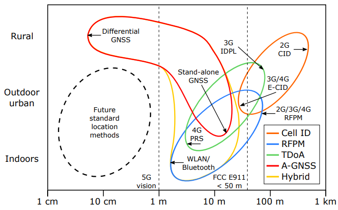
Image Source : Survey of Cellular Mobile Radio Localization Methods: from 1G to 5G
Here’s a breakdown of the key elements (the area of application for specific technologies)
- Cell-ID based technology(Orange)
- Covers medium to large-scale positioning (from tens of meters to kilometers).
- Used in 2G, 3G, and 4G networks.
- Most applicable in urban and rural environments with coarse accuracy.
- Received Power Fingerprinting (RFPM) (Blue)
- Covers indoor to urban outdoor environments, typically in the 10m to 100m range.
- Often used in Wi-Fi-based positioning and network-based techniques.
- Time Difference of Arrival (TDoA) (Green)
- Provides higher accuracy (1m to 100m) compared to Cell-ID and RFPM.
- Used in 3G, 4G, and future 5G networks.
- Works better in urban and mixed environments.
- A-GNSS (Red)
- Covers standalone GNSS and differential GNSS technologies.
- Offers higher accuracy in rural and outdoor urban environments.
- Used in outdoor navigation but has limited indoor usability.
- Hybrid (Yellow)
- A combination of multiple techniques (e.g., GNSS + Wi-Fi + RFPM).
- Provides a broad coverage area from indoor positioning to rural GNSS-based localization.
- Often used in E911 emergency services, FCC compliance, and multi-sensor positioning solutions.
5G and NR (Next-Generation Radio) networks were expected to enhance positioning services. These services matter for E911 emergency calls, logistics, and autonomous vehicles. However, there is a difference between what 5G positioning promised and what it achieves. This article compares the expectations with the current challenges.
Expectations: The Ideal Vision for 5G Positioning
5G positioning technology was expected to outperform LTE. Here’s what was promised:
- Centimeter-Level Precision : 5G was expected to achieve accuracy within centimeters. It would use wideband Positioning Reference Signal (PRS) and beamforming techniques. Millimeter-wave (mmWave) and terahertz (THz) spectrum would enable this.
- Diverse Positioning Techniques Integration : Techniques like Time of Arrival (TOA), Time Difference of Arrival (TDOA), Angle of Arrival (AoA), and Observed Time Difference of Arrival (OTDOA) were expected to combine. These would support positioning in various environments. The aim was tracking indoors and outdoors without issues.
- Integration with Smart Cities and Autonomous Systems : 5G positioning was expected to function well in cities. It would aid autonomous driving, smart city systems, and robotic navigation. This would be better than GPS.
Reality: The Challenges of Positioning
5G positioning has not reached its goals. Below are the challenges, split into UE-side and network-side realities:
- UE-Side Reality (User Equipment Limitations)
- 5G positioning depends on the network, not the device. Most UE (smartphones, IoT devices) cannot handle TOA, TDOA, or AoA signals. They lack the needed hardware and algorithms.
- Devices rely on GPS and Wi-Fi for positioning. This restricts standalone 5G positioning in consumer products.
- Network-Side Reality
- Limitations of PRS (Positioning Reference Signal) : PRS was introduced in 5G NR to boost accuracy. But it depends on signal strength measurements. It improves on Synchronization Signal Block (SSB)-based localization. Still, errors can reach several meters. This is not enough for autonomous driving.
- Indoor Positioning Challenges : 5G was expected to excel indoors. However, Wi-Fi positioning is often more accurate. AoA-based techniques could help indoors. But most devices do not support them. Wi-Fi remains the preferred choice.
- Lack of a Strong Business Model for Network Operators : Network operators must support 5G positioning. Yet GPS and Wi-Fi meet most needs already. Operators have little reason to invest. Without a revenue model, they avoid deploying 5G positioning services.
Reality: Industry/Standard
- Poor Integration of Techniques : The industry proposed many techniques like TOA, TDOA, AoA, and OTDOA. But it has not created effective solutions to integrate them. These methods do not perform well across all conditions, such as outdoor, indoor, or various RAN (Radio Access Network) technologies. The standards lack a cohesive plan for reliable positioning everywhere.
- Inconsistent Testing and Validation : Testing and validation of these techniques have been inconsistent. Different vendors and operators use different approaches. This creates compatibility issues across networks and devices.
- Lack of Adaptive Framework : The standards bodies, like 3GPP, have focused on individual methods. They have not prioritized a framework to adapt positioning dynamically to different scenarios, such as dense urban areas or rural regions.
- Weak Industry Collaboration : Limited collaboration between hardware manufacturers and software developers slows progress. For example, integrating 5G positioning with existing GNSS (Global Navigation Satellite System) solutions remains underdeveloped.
Summary and the Future of 5G Positioning (Another expectation ? :)
5G positioning promised high accuracy and reliability. But it faces significant hurdles today. In other words, 5G positioning holds potential. However, it has not overtaken GPS or Wi-Fi yet. Advances in hardware, networks, and business strategies are necessary to fulfill its promise.
- Current Realities in Positioning Technologies:
- Outdoor Positioning: GPS is the primary method. Cell ID and Wi-Fi SSID assist.
- Indoor Positioning: Wi-Fi-based localization is the most effective.
- Emergency Services (E911, PSAP, E-Call): Uses GPS, Cell ID, and Wi-Fi data.
- Future Outlook for 5G Positioning:
- PRS and AoA-based positioning may improve over time.
- Network operators may discover new revenue models.
- Hybrid solutions combining Wi-Fi, 5G, and satellites could emerge.
Many regions have regulations requiring positioning for emergency services like E911. These rules specify how location data must be provided, involving both User Equipment (UE) and network (NW) roles. Below is an overview of key regional regulations and their implementation, based on current standards as of February 26, 2025.
United States
- Regulation
- The Federal Communications Commission (FCC) mandates positioning for E911 across wireless, VoIP, and multi-line telephone systems (MLTS):
- Wireless E911: Phase I requires cell site location and caller number. Phase II demands latitude/longitude within 50–300 meters. Since 2022, vertical (z-axis) accuracy of ±3 meters is required for 80% of indoor calls in top markets.
- VoIP E911: Providers must transmit registered location and number to PSAPs. Kari’s Law (2020) ensures direct 911 dialing. RAY BAUM’s Act (2021–2022) requires “dispatchable location” (e.g., floor/room).
- State Variations: Some states add stricter rules, like precise MLTS location or campus notifications.
- Implementation
- UE Role:
- Sends serving cell ID to the network during call setup for Phase I.
- Provides GPS coordinates if enabled, using GNSS for Phase II precision.
- Reports signal measurements (e.g., RSRP, Timing Advance) for network triangulation or OTDOA.
- For z-axis, some UEs with barometers report altitude, though this is limited.
- NW Role:
- Maps cell ID to tower location for Phase I delivery to PSAPs.
- Calculates position using UE signal data (e.g., TDOA) or fuses it with GPS for Phase II.
- Estimates z-axis using tower data or building records if UE lacks altitude capability.
- Ensures VoIP calls route registered address and MLTS provides dispatchable details.
Canada
- Regulation
- The Canadian Radio-television and Telecommunications Commission (CRTC) oversees 911 positioning:
- VoIP providers must send location (registered address) to PSAPs.
- Wireless carriers must provide approximate location data, though rural accuracy is less stringent.
- Next Generation 911 (NG911) plans aim to improve precision, but no z-axis mandate exists yet.
- Implementation
- UE Role:
- Transmits cell ID to identify the connected tower.
- Sends GPS data if available, though not always required in rural areas.
- Provides basic signal measurements for network-based positioning.
- NW Role:
- Maps cell ID to approximate tower location for PSAPs.
- Uses triangulation from UE signal reports in urban areas; relies on cell ID alone in rural zones.
- Routes VoIP calls with registered address; no advanced indoor methods deployed widely.
European Union
- Regulation
- The EU regulates E112 under the Universal Service Directive and European Electronic Communications Code:
- Caller location must be provided for all calls (mobile, VoIP).
- Accuracy varies by country; no uniform meter-specific standard exists.
- eCall (vehicle emergency) mandates automatic location via GNSS.
- Implementation
- UE Role:
- Sends cell ID to the network for basic location.
- Uses GPS/GNSS to provide coordinates when available, especially for eCall.
- Reports signal data (e.g., timing differences) for network methods like OTDOA.
- NW Role:
- Delivers cell tower location to emergency services.
- Calculates position using UE signal data or enhances with network-based triangulation.
- For eCall, processes UE GNSS data and forwards it instantly.
Other Regions
- Australia
- Regulation: The Telecommunications (Emergency Call Service) Determination requires location for 000 calls, primarily via triangulation or GPS.
- UE Role: Sends cell ID and GPS data if enabled; reports signal strength.
- NW Role: Maps cell ID to tower location; triangulates using UE data; no indoor precision mandate.
- India
- Regulation: TRAI mandates location for 112/100 calls, but enforcement varies.
- UE Role: Provides cell ID and GPS when available; limited signal reporting.
- NW Role: Uses cell ID mapping; triangulation spotty, especially in rural areas.
- Japan
- Regulation: Carriers must provide approximate coordinates for 110/119 calls.
- UE Role: Sends cell ID and GPS data; minimal signal measurement reporting.
- NW Role: Maps cell ID to location; fuses with GPS when provided; no vertical focus.
Key Observations
- U.S. Leadership: The FCC’s detailed rules (e.g., z-axis, dispatchable location) push UE and NW to deliver precise data, with strong enforcement.
- Global Variation: Other regions focus on basic location (cell ID, GPS), with less emphasis on indoor or vertical accuracy.
- UE Limitations: Across regions, UEs mainly provide cell ID and GPS, relying on NW for computation and delivery.
- NW Dominance: Networks handle most positioning logic, compensating for UE constraints, especially indoors or in rural areas.
Reference :
YouTube
|
|