Wireless communication is mandatory for any kind of drone / UAV unless you want to fly those with long signal line attached between you and drone like flying a kite.
What that link has to carry is where the subject widens. A toy needs one link and nothing else. A camera drone needs a second one for the pictures. A military aircraft flown from another continent needs four, and two of them go through a satellite. The three photographs below are the same question asked at three scales.
- How many links does a drone need ?
- Why a drone link reaches so far
- What altitude does to everyone else
- YouTube
- Reference
How many links does a drone need ?
Counting the links is the quickest way into the subject, because the count rises with what the aircraft is for rather than with how expensive it is. Each new job the drone is given adds a link, and each link brings its own direction, its own rate and its own tolerance for delay.
Even a super cheap toy drone as below use a wireless communication between the controller and the drone. Usually they would use analog communication in unlicensed band.
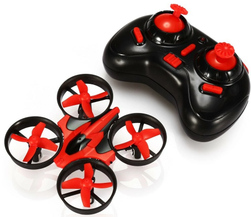
Figure 1. The simplest case, and a photograph rather than a diagram. One controller, one aircraft, one link, and nothing coming back except whatever the pilot can see with their own eyes.
The controller has two sticks and no screen : nothing is displayed because nothing is sent back. The link runs one way in practice, from the hand to the aircraft.The pilot is the feedback path : position and attitude reach the operator by eye, which is why this class of aircraft only works within sight.Ducted propellers put the aircraft indoors : the guards around each rotor mark this as a machine flown at short range. A low power unlicensed link is enough there.
A little bit higher cost drone as shown below use wireless communication in most case with multiple communication link. Mainly using a link for drone control and another links to retrieve various data from drone (like video image). The communication technology between these links can be same or different. For example, they can use analog communication for drone control and digital communication (like WiFi) for data. Or they can use the same / similar communication for both. For example, analog communication for both controller and data, or digital communication (like WiFi) for both control and data.
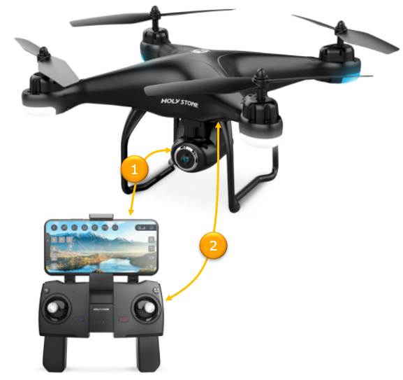
Figure 2. The same picture with a camera added, and the camera is what forces a second link. The two orange circles number them, and they are not alike in any respect except that both are radio.
Circle 1 runs from the gimbal camera to the phone : the phone is clipped to the controller and is showing a landscape. This link carries the video and nothing else.Circle 2 joins the aircraft to the controller itself : the sticks are here rather than on the phone, which is the split the picture is drawing.Both arrowheads point at the ground : that reads correctly for the video, and control information travels the other way, from the sticks up to the aircraft.The two links want opposite things : video wants rate and tolerates a dropped frame. Control wants latency and reliability, and needs almost no rate.
One of the most complicated communication technology for UAV/drone would be something like military applicated as illustrated below. The numbered circle in the illustration indicates wireless link. In most case, in this case the radio link would be licensed or dedicated spectrum not open to public and the communication would be highly encrypted.
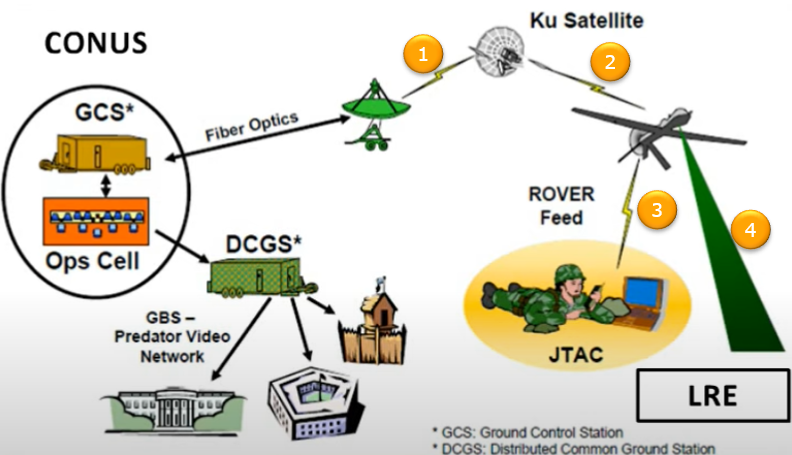
Figure 3. Four numbered links, and the reason there are four is that no single one can do every job. Two of them go through a satellite to reach an aircraft on another continent, and the other two stay local.
Circles 1 and 2 are one path in two hops : ground dish up to the Ku satellite, and satellite down to the aircraft. Together they carry control beyond the horizon, which no direct link can do.Circle 3 is the ROVER feed : video straight from the aircraft to the JTAC on the ground. It bypasses the whole ground station chain, because the person who needs the picture is underneath it.Circle 4 reaches the LRE : a local link drawn as a wide green beam, separate from everything going through the satellite.Only the left hand side is wired : the arrow into the ground control station is labelled Fiber Optics. The ops cell, DCGS and the buildings it feeds are joined by lines rather than by radio.The figure expands two of its abbreviations and not the rest : the footnotes give GCS and DCGS. CONUS, JTAC, ROVER, GBS and LRE are left as they are.
The fourth link is the one worth asking about, because the satellite path already reaches the aircraft. The answer is delay. A geostationary satellite sits 35786 km up, so one hop costs 119 ms. A command with an acknowledgement crosses the link four times, for something near 477 ms.
Half a second is tolerable for a cruising aircraft and not for one landing. The local link at circle 4 keeps the phase needing the tightest control off the satellite entirely. The split between the two paths is a latency decision rather than a coverage one.
The link count follows the mission, not the price : one for a toy and two once a camera is fitted. Four when the aircraft must be flown beyond the horizon and watched locally at once.Control and payload separate first : they want different things from the radio. They stop sharing a link as soon as there is a payload worth sending.Beyond line of sight costs half a second : a geostationary hop is the only way to reach another continent and it is too slow for the landing.The ground segment is mostly not radio : in Figure 3 the fibre and the wired distribution carry the data once it is down. The radio links are only the first and last steps.
Source : Unmanned Aircraft Systems - A Lecture on UAS Basics by Unmanned Experts
Why a drone link reaches so far
A toy flown across a garden and a camera drone sold with a range in kilometres often share a band and a power class. The radio is not what separates them. Height is, and the effect is larger than it looks.
A radio link needs a clear path, and on a round planet the path ends at the horizon. The distance to it is the square root of twice the Earth radius times the height, which grows quickly at first and slowly afterwards. Figure 4 draws the geometry with the curvature exaggerated so that the two tangents can be told apart.
Figure 4. Why 120 m of altitude is worth so much. The tangent from the drone touches the surface almost nine times further away than the tangent from a standing operator, and the radio is unchanged.
Both dashed lines are tangents to the same surface : each ends where the ground curves away. Only the starting height differs.The square root is what makes low altitude valuable : the first few metres buy a great deal of range and the next few hundred buy proportionally less.The drawing exaggerates the curve : at true scale the Earth would look flat across this width and neither tangent would be visible.
The table puts numbers against a few heights. The last column is the area a transmitter at that height can reach, and it grows as the square of the horizon rather than in proportion to it.
Height |
What that is |
Horizon |
With refraction |
Area in view |
1.5 m |
a standing operator |
4.4 km |
5.0 km |
60 square km |
10 m |
a rooftop or a short mast |
11.3 km |
13.0 km |
400 square km |
120 m |
the ceiling most drone rules set |
39.1 km |
45.2 km |
4804 square km |
500 m |
a survey aircraft |
79.8 km |
92.2 km |
20015 square km |
3000 m |
a light aircraft |
195.5 km |
225.8 km |
120091 square km |
Putting the two ends together gives the usable range. A drone at 120 m and an operator at 1.5 m see each other until the two horizons meet. That is 39.1 plus 4.4, or 43.5 km. Two people standing on the ground manage 8.7 km between them, so the altitude has bought a factor of five with no extra power.
The second gain is quieter and just as large. A path with nothing in it loses only what free space takes, which at 2.4 GHz is 100 dB over one kilometre and 120 dB over ten. Twenty decibels for ten times the distance is the best case any link can have. A ground link between two people never gets it, because buildings and terrain add far more.
Height beats power : the horizon is geometry, and no amount of transmit power extends a path the Earth is blocking.39 km from 120 m : and 45 km once atmospheric refraction is counted, which bends the path slightly around the curve.The two horizons add : the link closes when the aircraft and the ground station can both see the same point, so each end contributes its own square root.Clear line of sight is worth more than the range : 20 dB per decade of distance is the free space law. A cluttered ground path loses much faster.
What altitude does to everyone else
Everything in the section above is good news for the drone and bad news for the network around it. A clear path is not a private path. The same geometry that lets a drone be heard a long way off also lets it hear, and be heard by, a great deal that a ground terminal never touches.
The area column in the table is the measure of it. A transmitter at 1.5 m can reach about 60 square kilometres, and one at 120 m reaches roughly 4800. The drone therefore shares the band with something like eighty times as many other users as the operator standing underneath it.
For a drone carrying a cellular module the consequence is specific. Base station antennas are tilted downward to serve people on the ground, so an aircraft above them sits in the upper sidelobes of many cells at once. It receives a serving cell that is barely stronger than a dozen others, which is the condition under which handover becomes unstable and throughput falls.
The uplink is worse, because it is the one direction where a single aircraft affects everybody. A transmission from 120 m arrives at cells tens of kilometres away with a clear path. It raises the noise floor across all of them, rather than being absorbed by the first building. One drone is a wide area interferer in a way that one phone is not.
The cause is not speed. A drone at 20 m/s shifts a 2.4 GHz carrier by 160 Hz and a 5.8 GHz carrier by 387 Hz. Both are small beside the Doppler a train or a car produces at cellular frequencies. The difficulty is the clear path, not the movement.
Line of sight helps in both directions : the property that makes the link long also makes the aircraft audible to every receiver inside that same horizon.Eighty times the area, eighty times the neighbours : 4800 square kilometres against 60, from 120 m of height.Downtilted antennas leave no dominant server : an aircraft above the main beams sees many cells at similar strength, which is the worst case for cell selection.The uplink is the shared cost : a drone transmission reaches far more cells than a ground transmission, and each of them counts it as noise.Speed is not the problem : 160 Hz of Doppler at 2.4 GHz is modest. Altitude rather than velocity makes a drone a hard case.
YouTube
- Unmanned Aircraft Systems - A Lecture on UAS Basics by Unmanned Experts (Dec 2013)
- The Technology Behind....How The New DJI Spark Remote Control Works (Jun 2017)
- Wireless Communications with Unmanned Aerial Vehicles (Dec 2017)
- Wireless Communications with Unmanned Aerial Vehicles - Wireless @ Virginia Tech (Dec 2017)
- Drone Communication (Jan 2019)
- BEST DRONE RADIO FOR BEGINNERS - Frsky x9 lite review (Aug 2019)
- Beginner Series: Transmitter Explained - Drone Radio, Drone Controller, which to chose? (Mar 2020)
- Radio Knowledge for Drone Pilots - Part 1: Radio Theory (Feb 2021)
- Radio Knowledge for Drone Pilots - Part 2: When to Use a Radio (Feb 2021)
- Radio Knowledge for Drone Pilots - Part 3: Etiquette (Mar 2021)
- SmartAP AIRLink - The Most Advanced AI Drone Avionics (Apr 2021)
- IEEE VTS Webinar on AAM: Accessing from the Sky: UAV Communications for 5G & Beyond - IEEE VTS (2023)
Reference
[1] Unmanned Aircraft Systems, A Lecture on UAS Basics, Unmanned Experts, which is the source Figure 3 is taken from.